corona arch
景点印象
SMS-MJS
Beautiful. Easy to moderate hike - on way to Canyonlands. Plenty of parking. Follow cairns (rock piles) which lead the way to all outdoor sights in the Moab area.
TLHKNXG
Well worth the 1.5 mile hike from UT 279 and just 12 miles from Arches NP. The 110 ft opening is huge and the slickrock canyon around it is beautiful. One of the best arches in the United States. Completely exposed to the sun though. Bring plenty of water on hot days.
856lawrenceg
About a 20 mile ride to the trailhead on the Potash Road, but only a short hike in to one of the biggest arches in Canyonlands. Don't miss the kairn factory about halfway in.
PatH13
Went into Arches Natl Park and the scenery was stunning. We finally made our way to where the Arch was. WE hiked for about 45 minutes to get there. We had my 2 small grandchildren with us. The hike up was not bad even with small kids. What a stunning sight when we got there. I recommend you stay either in the park or Moab for 3 or 4 days. The park is huge and Canyons Natl Park is on the other side of Moab. Highly recommend you to visit this area. Perfect family vacation.
K5285NXsarahc
Beautiful views, amazing arch, but lots of people. Start early in the morning to avoid the heat of the day. There is very little shade on this one. There is one section where you have to climb on cables and then up a ladder. All the reviews I read said it was good for kids. We took out 3 year old, who is very adventurous and she did great with dad's help. We will definitely be back!
HCT1962
There are no signs or local indicators of where to find this arch so do your research in advance on how to get there.Definitely worth a visit though, it’s a pretty good walk up from the parking area to the arch.Getting up close you realise how massively impressive these arches are.
MaralynT
Our crew arrived in Moab & settled into our hotel leaving just the afternoon & evening of our 1st day for sightseeing. We had never done Corona Arch in previous trips, so we drove about 8 miles out of Moab on Potash Rd to the Arch. The hike is a gradual climb at 1st but then you have to climb up a ladder & hang onto a chain in some sections. But it is worth the hike & we saw lots of families & dogs making it up. The Arch itself is pretty impressive but the highlight of our day was running into the crew from the TV show Trip Flip on the Travel Channel. They were filming some guys swinging on ropes through the Arch. The program will be airing in late winter or early Spring - so watch for it. After the hike, we stopped to look at the Indian pictographs along the road. It was a great way to spend a half a day before moving on to Arches, Dead Horse State Park & Canyonlands.
226ernestp
Not in any of the parks, a little bit of a hike with some climbing up some slip rock and a short ladder. don't bring dogs (tough) to make it up the cliff. Awesome arch (huge), fun hike. GO!
virgoqueenliz
Didn't make it up the rope part or ladder with my dog but had a nice view from right before it. It's nice and easy.
UCLA72
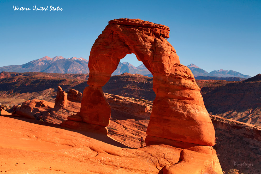
If you have already been to well-known Delicate Arch in Arches National Park and/or want to take a path less-travelled, try Corona Arch. The hike is uphill, a bit over a mile, and has a few fun challenges along the way. Take plenty of water as the trail is mostly in the sun. In winter take traction devices for your boots and perhaps poles if there is ice. Be prepared for a real treat at the end. Highly recommend.
seane383
This is a great family hike. You can go as far as you like, but the payoff is at the end when you can actually get directly to the arch. It's mostly flat, but there are a few place that require stairs/ladder. My son loves running around the red rock.
WyKB02
This is a great hike and unlike Arches National Park dogs are welcome. Having said that, our only concern would be the amount of dogs that aren't on their leash. Most are fine, but you always have those few dog owners who can't keep there's under voice command. Not all dogs enjoy one another. Enough said! Corona Arch is quite large and when you stand under it, it is an amazing feeling. The hike is more adventuresome due to the cable stairway and the ladder, but that's what I find enjoyable. It's not just a simple trail hike. Corona should not be missed if your in Moab.
Alaskaseeker
UTAH SR279-THE POTASH ROAD) (UTAH’S HIDDEN BYWAYS XII) Every years, thousands of vehicles leave Moab, Utah heading north on Utah SR191, searching for adventure at Arches or Canyonlands National Parks, or along Utah SR128 (see TripAdvisor, Utah 128, UTAH’S HIDDEN BYWAYS II). What these travelers do not realize is that they are by-passing one of the more scenic roads in the area, and a route that contains many hidden gems. This route is Utah SR279, an easy drive (paved) along the Colorado River to a Potash Plant, followed by a more difficult dirt track that becomes the back door onto the White Rim jeep roads of Canyonlands National Park. Utah SR279 is an fascinating paved road that parallels the Colorado River opposite Moab, Utah, for about 8-10 miles. This route traverses an extraordinary area of Entrada and Navajo Sandstone, eroded by wind, ice, and water over geologic times. These fanciful Buttes, Arches, Spires, and Mesas with unique names, as well as hoodoos of exceptional shapes and colors, give the traveler a short trip through geologic time. The colors and shadows emanating from these eroding structures and monoliths produce visual images that make this area highly photogenic, especially when reflected in the Colorado River. Furthermore, this road is not that difficult to drive on for the first few miles (i.e. up to the Potash Plant), as long as simple precautions are observed. To access this route, head north out of Moab on Utah SR191N, crossing the Colorado River. Keep to the LEFT lane and make a left turn at the SR279 sign. You are now on the scenic byway SR279. As you proceed, you will have the Colorado River on your left. The sandstone walls on your right, where much of the activity will be, are best viewed in the mid-morning light. Photographically, this gives the best color and shadows on the red rock walls. There are numerous pull-outs on your right, with specific attractions to be examined. You will encounter one for dinosaur tracks, one for petroglyphs (see image), and the trailhead to Corona Arch. Stop at each feature and examine what nature has left us. If you plan to go to Corona Arch, an early start is recommended due to parking limitations. This is generally a moderate to strenuous hike involving some initial scrambling, chains, and ladders. Bring water, sensible shoes, some food, and a first aid kit. As you leave the parking area, there is a rough trail with a scramble to attain the level of the railroad tracks, which must be carefully crossed. The going gets easier, and hotter, as you traverse the red rock bench area, with Gold Bar Arch about a half mile to your left. The trail will angle to your left, and Corona Arch will soon be visible (see image). As you continue, you will have to surmount ridges of red rock, using the aforementioned chains and ladders. The trail does continue, passing Bow-Tie Arch to your left, to your destination of Corona Arch. This arch is best viewed, from a photographic point of view, in the late morning, early afternoon. It is a shame that some narrow minded individuals have, on occasion, ruined the view by turning Corona Arch into their own private playground. Their attachment of ropes to the upper section of the arch and use of the arch as a swing for cheap thrills degrades the area. The BLM will be ruling, and hopefully banning, this behavior, allowing all to see Corona Arch as nature intended it to be seen. The way back to your vehicle is the way that you came in. Bow-Tie Arch, on your right, will be in better lighting in late morning, early afternoon light. If you continue along the Potash Road (SR 279), you will encounter Jughandle Arch on your right (see image). If you cannot find it, look above your head, close to the wall. This arch is best seen, and photographed, in the late morning. You will also encounter boat launching facilities, with their parking areas for buses, on the river side of the road. These boats, which are owned and operated by the various tour vendors in Moab, travel down the Colorado River as far as the confluence with the Green River or points closer in. The paved road will terminate at the Potash Plant. IF YOU GO BEYOND THE PAVED ROAD AT THE POTASH PLANT, PLEASE READ, AND HEED, THE FOLLOWING: DO NOT ATTEMPT THIS TRACK IF IT HAS RAINED WITHIN THE LAST 24 HOURS. USING A VEHICLE WITH SOME HIGH CLEARANCE AND FOUR WHEEL DRIVE, SUCH AS AN SUV OR JEEP TYPE, IS MANDETORY. I AM NOT KIDDING!!! FURTHERMORE, ALWAYS BRING WATER, FOOD, AND EMERGENCY EQUIPMENT FOR YOUR VEHICLE AND YOUESELF. A GOOD AREA MAP IS ESSENTIAL BEFORE ATTEMPTING THIS MORE AMBITIOUS UNDERTAKING. If you decide to go off the paved road and are aware of the aforementioned warnings, the dirt/gravel track will eventually take you to a red rock bench at the ox-bow of the Colorado River below Dead Horse Point State Park. These jeep tracks can been seen from the Dead Horse Point viewpoint, as seen on an attached image in my TripAdvisor submission entitled “Green River Overlook-Canyonlands National Park (UTAH’S HIDDEN BYWAYS XI). Stop frequently as you swing around this point for various views. You will also find numerous “social trails” (i.e. not official) on your right. You may want to take some of these trails to improve your photographic angles and lighting. Continuing along will get you into Canyonlands National Park, where you will join up with the White Rim Trail (i.e. dirt road). A right turn will take you onto the switchbacks and up to the Island in the Sky section of the park. A left turn will take you into some adventure and fantastic scenery. Places like Musselman Arch, a reverse view of the Washer Woman Arch, and Monument Basin are all in front of you. If you plan to go to Monument Basin, register at the Ranger Station and give yourself a full day. Having done this day trip with a jeep and a guide (i.e. Tag-a-Long Tours), I can tell you that it is well worth the time and expense. DO NOT DEFACE THE ROCKS OR ITS SURROUNDINGS. YOU ARE ON STATE/FEDERAL PROPERTY, AND IT IS AGAINST THE LAW. LEAVE IT THE WAY NATURE INTENDED IT TO BE LEFT! You can backtrack on SR279, make a right onto SR191S (main road) for your trip back to Moab. Make a left onto SR191N if you are heading toward Interstate 70E and W.Enjoy the trip and be safe. ALASKASEEKER (B.I.N.)
davesB459XL
Yet another remarkable spot. Mostly easy with a short ladded to climb near the end. This is a great half-day hike.
JeffS228
While on an extended motorcycle trip from Minnesota to Utah, we stopped for two nights in Moab to visit Arches National Monument. Like many others, we have seen pictures, but never visited the Arches. What a wonderful experience! Being limited for time, we did not get into some of the places we had hoped.